
3DBAG: groundbreaking open data project in 3D
 The 3DBAG brings the Netherlands to life in 3 dimensions. With over 10 million digitally reconstructed buildings, the 3DBAG is one of the country’s most comprehensive open datasets. What began as a research project at Delft University of Technology (TU Delft) has become an essential resource for local authorities, researchers, and businesses. Now, thanks to the Innovation Budget, the 3DBAG is set for further expansion.
Jantien Stoter of TU Delft and Geonovum explains: “The 3DBAG -short in Dutch for 3D Basic Registration of Addresses and Buildings- is a dataset containing 3D models of every building in the Netherlands. We create these models using algorithms that draw on open data. The results are not only visually striking but also highly practical. Local councils use them for urban planning and climate research, helping to shape policies that reflect real-world conditions. Researchers and professionals rely on the data for noise mapping and energy consumption studies. This makes the 3DBAG an incredibly versatile resource.”
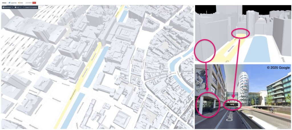
Better visibility of canopies
The Ministry of the Interior and Kingdom Relations (BZK) aims to stimulate collaboration and innovation among government organisations through the Innovation Budget (Dutch). This fund is open to all Dutch public authorities, including provinces, municipalities, water authorities, ministries and implementing organisations. The Innovation Budget is currently funding the development of advanced algorithms to improve the visibility of complex building structures.
At present, features such as underpasses and canopies are not clearly represented, which was precisely why the project was submitted for Innovation Budget funding. Stoter explains: “A pedestrian passage or canopy appears closed from the air, even though there is open space beneath it. In the current dataset, these are shown as solid blocks, which can lead to inaccurate calculations. We’re delighted that our project has been selected for the Innovation Budget. Now we can develop new solutions. For example, using oblique aerial photographs or mobile laser scans. This will make the 3DBAG just that little bit smarter.”
Connecting to practice
Participation in the Innovation Budget requires working with open source, which, for 3DBAG, was a given. “Other parties can use, improve and expand our code, which helps to enhance its quality,” says Stoter. “This approach is advantageous. For example, two municipalities and two provinces have developed an open web platform (Dutch) based on the 3DBAG. A developer community has also been established, involving international experts. Because we share knowledge with so many parties, the dataset is becoming increasingly aligned with real-world practice.”
Building together
New insights, improved measurement methods, and technological developments ensure that the dataset continues to improve. But according to Stoter, the 3DBAG will never be finished. “We can create all kinds of smart algorithms, but the quality of the result depends on good source data. That’s why we work with many parties to continuously improve the data. This creates a large network of data and expertise. Thanks to the combination of open data, smart algorithms and close cooperation, the Netherlands is truly at the forefront with the 3DBAG.”
More about 3DBAG
The 3DBAG innovation project is a collaboration between Delft University of Technology (TU Delft), 3DGI, the Ministry of Housing, Spatial Planning and the Environment (VRO), the National Institute for Public Health and the Environment (RIVM), the Netherlands Enterprise Agency (RVO), the municipalities of Utrecht and Amsterdam, the Land Registry (Kadaster), the Dutch Water Authorities (Het Waterschapshuis) and Geonovum. Together, they form the 3DBAG Innovation Platform. Here, government bodies, research institutes and companies work together on the future development of the 3DBAG.
Files on this theme
BAG
The Key register Addresses and Buildings (in Dutch: Basisregistratie Adressen en Gebouwen, BAG) contains municipal basic data of all addresses and buildings inside the municipality. Copies of these data are collected in a National Facility (Landelijke Voorziening, BAG LV). The Dutch land registration organisation Kadaster manages the BAG LV, and provides data to public offices, institutions, companies, and private citizens. The Minister of the Interior and Kingdom Relations is responsible for the BAG system.
Base registries
There are 10 base registers. Base registers have been officially instated by the government as the mandatory data registration sources for all governmental institutions when executing their public duties. Their application varies: from the turning out of emergency response services, and the efficient determination of a claim on benefits, to the appraisal of a license application. The citizen’s privacy is guaranteed when these data are used.
BGT
The Key register Large-scale Topography (in Dutch: Basisregistratie Grootschalige Topografie, BGT) is a digital map of the Netherlands, which records buildings, roads, waterways, land, and railway lines in a uniform way. The map is accurate up to 20 centimeters and contains many details, just as you would see in reality. In short, it documents the spatial organization of our physical surroundings: trees, roads, buildings.
BRI
The Key register Income (Basisregistratie Inkomen, BRI) contains the total income or taxable annual income of everybody who files an income tax return. Government organisations use the BRI to determine supplements, subsidies, or benefits. The income registered in the BRI is called the registered income. You can view your registered income (of the previous year) on MijnOverheid (MyGovernment).
BRK
The Key register Kadaster (Basisregistratie Kadaster, BRK) consists of the cadastral registration and the cadastral map (Kadastrale Kaart). The cadastral data are used by many clients as the foundation for their own work processes. In that sense, the Kadaster has been a key register for a long time. The Kadaster’s products remain available through MijnKadaster and the other channels. Direct links to other key registers will enable incorporation of the data of other registers into the cadastral register and products.
BRO
The Key register Subsoil (Basisregistratie Ondergrond, BRO) is to become the central database containing all public data on the Dutch subsoil. The BRO Act, which came into effect on 1 January 2018, requires that source data owners provide and use soil and underground data in a digital form. The requirements will be expanded step by step in the next 4 years. The data in this key register have been validated and are of importance for activities like fresh water procurement, underground transport, and mineral mining, but also for activities on the surface, like energy transition, housing construction, and infrastructural projects.
BRP
The Key register Persons (Basisregistratie Personen, BRP) is the key register for personal data within the key register system. The Dutch government uses the data recorded in the BRP. Amongst other things, these are: name, date and place of birth, address, and familial relations. Other organizations also use the BRP data, for instance pension funds and research institutions.
BRT
The Key register Topography (Basisregistratie Topgrafie, BRT) consists of digital topographic files on different scale levels (scale: 1:10.000, 1:50.000, 1:100.000, 1:250.000, 1:500.000, and 1:1.000.000). The Netherlands Cadastre or Kadaster manages the BRT. This collection of topographic files is available as open data. This means that the Kadaster makes these data files available free of charge, and subject to minimal delivery conditions.
BRV
The Key register Vehicles (Basisregistratie Voertuigen, BRV) lists data of vehicles, vehicle registration documents, and persons to whom the vehicle registration document was assigned. The Netherlands Vehicle Authority (RDW, Dienst Wegverkeer) provides information from the register to authorities, citizens, and businesses.
Citizen Service Number Management Facility (BV BSN)
The Citizen Service Number Management Facility (BV BSN) encompasses the set of provisions responsible for managing the Citizen Service Number (BSN). Organisations that utilise the BSN, such as municipalities or other government agencies, can access the BV BSN. Core functions of the Citizen Service Number Management Facility Number generator for issuing Citizen Service Numbers: The BV BSN generates Citizen Service Numbers and allocates them to municipalities. Number register for recording Citizen Service Numbers: The BV BSN's number register logs which municipality a BSN is assigned to and the issuance date of the BSN. It also tracks the status and history of the BSN. Presence queries: By initiating presence queries, municipalities can prevent the assignment of multiple numbers to a single individual. Verification queries: These are used to validate the accuracy and authenticity of the BSNs and associated data.
Digikoppeling
Digikoppeling (‘Digilink’) consists of standards for interfaces, containing agreements for the exchange of messages between authorities. One Digikoppeling implementation in an IT-environment enables you to exchange messages with all authorities, and to join nearly all eOverheidbouwsstenen (e-Government Building Blocks), for instance the key registers. Governmental as well as private organisations that perform a public task can use Digikoppeling.
Digilevering
Digilevering (‘Digidelivery’) is one of the system services. Digilevering distributes up-to-date and accurate key register data to key register clients in the shape of event messages, for instance relocation of a company, the birth of a person, or a change in somebody’s income. Each receiving organization is responsible for determining which data are relevant.
Digimelding
The information stored in key registers has to be up-to-date and reliable. One of the tools used to guarantee the quality of the key registers is Digimelding (‘Diginotification’), which enables users to ‘report back’. All users of the key registers have a legal duty to report any data that they know could be wrong. Reporting back contributes to efficient operations management within the government, improves the level of service, and increases the opportunities to fight fraud.
HR
The Trade Register (Handelsregister, HR) is the base register containing all businesses and legal entities. All other economic actors are also listed in this register. This guarantees legal security when doing business. All government bodies will we required to make use of this register. For instance, a municipality will have to consult the Trade Register when searching for a company’s details.
NORA
The purpose of the Netherlands Government Reference Architecture (Nederlandse Overheid Referentie Architectuur, NORA) is to be a guiding and driving tool. It contains frameworks and existing agreements for the lay-out of the Dutch governmental information management system. Realising services within the scope of these frameworks and agreements ensures smooth cooperation with other services, and optimal re-use of existing solutions.
System Catalogue
Data from the key registers form the axis for multiple use of data within the government. The System Catalogue makes visible which data the Key register System contains, what they mean, and how they are interconnected. The System Catalogue is targeted to inform policy makers and legislation lawyers.
System services
The smart exchange of data from the System of Key registers enables the government to operate more efficiently and to improve its service. Four System service support the key registers in their aim to disclose their catalogue of products and services to users in a uniform way. The System of Key registers identifies the following System services: Digikoppeling Digimelding Digilevering Stelselcatalogus.
WOZ
The data collection for the Key register WOZ (Waardebepaling Onroerende Zaken, or Valuation of Immovable Property) consists of several data, needed to relate this value both to an immovable property and to a stakeholder. These are: “Established value”(WOZ value), a BAG-listed address, and a link to cadastral parcels and/or addresses, and to BAG dwellings, stations, berths, and/or objects.